Nishi-Iya & Iyakei

Nishi-Iya & Iyakei

Lower and Central Iya Valley

Thrilling Views, Relaxing Onsen

The Kazurabashi Vine Bridge of Nishi-Iya

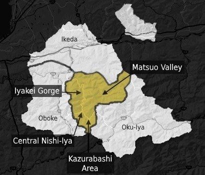
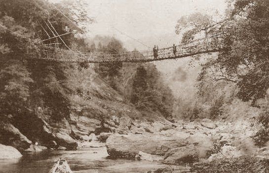
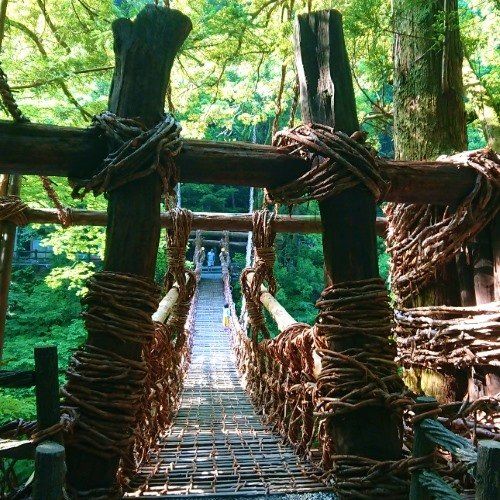
With its breathtaking viewpoints, top-notch hotels and hotsprings, various activities, and the renowned Iya-no-Kazurabashi Vine Bridge, the lower half of the Iya Valley is becoming an increasingly popular place to visit in recent years. 


Known as Nishi-Iya (East Iya), most visitors head directly to the famed vine bridge, which has a scattering of shops, restaurants, and places to stay surrounding it and is undoubtedly the most 'touristic' part of the Iya Valley (though its still a far cry from being overly so). At the vine bridge you'll usually see a tour bus (or three) bringing in day-trippers, but for 90% of them, this is all they see in the valley.


And while the vine bridge is certainly an amazing attraction, the rest of Nishi-Iya has a lot to offer. A steep gorge known as Iyakei covers the first 15km or so of the valley, and this pristine section is mostly undeveloped and uninhabited (with the exception of a single hotel, a campground, and a small statue). With the narrow, winding "Iya Highway" crawling along its cliffs offering fantastic views, independant travelers will be happy to know that most tour buses don't drive through the gorge and you'll often feel you have the place to yourself.


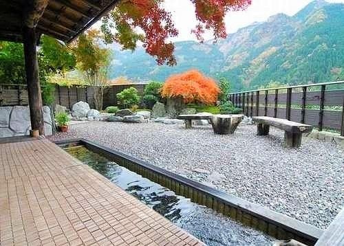
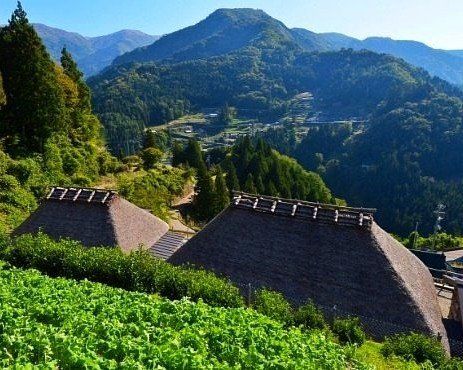
Within the Central Nishi-Iya and neighboring Kazurabashi Areas there's something for everyone, with hotsprings to relax in, outdoor activities like the zip-line and mountain monorail, riverside campgrounds, and plenty of chances to taste the famed Iya Soba noodles and other local delicacies. 


And for the truely intrepid, head over to the adjacent Matsuo Valley, which is known as the "Little Iya Valley". There's not much in the way of tourism or services within its steep walls, just of handful of tiny hamlets (many abandoned) and an utter feeling of isolation. The narrow, crumbling road through here links to Oku-Iya and makes for a truely off-the-beaten-path loop. 

The Iya Highway through Iyakei 

Nishi-Iya & Iyakei

Orientation

Located in the cener of Miyoshi, this area includes the lower half of the Iya Valley, which bisects it from the northwest to the southeast. 

The lowest portion of the valley is a 15km long, undeveloped gorge known as Iyakei, where the narrow "Iya Highway" threads itself along the cliff faces. 

In the south, Central Nishi-Iya is the most developed, with hotels, hotsprings, and several attractions, while the Kazurabashi Area nearby is home to the famed Vine Bridge as well as more places to stay and eat. Main roads connect these parts to Oku-Iya going east and to Oboke & Koboke going west.

Additionally, the northeast is home to the smaller and less developed Matsuo Valley. 

Climate of Nishi-Iya & Iyakei

The lowest points of the Iya Valley (as one enters the Iyakei Gorge area from Iyaguchi) have a similar temperature as Ikeda and Oboke, and in the summer it retains the same thick humidity. But as one enters the gorge at Deai, increasing in altitude and becoming enclosed by forest and mountains, the temperature begins to slowly drop. Upon reaching Central Nishi-Iya it can be a couple degrees cooler, while in the summer, it can be noticably less humid and muggy. In the autumn, the leaves near the Kazurabashi will begin to change color in late October and into mid-November, about a week or so before the lowest parts of the Iyakei gorge near Deai.

Though Nishi-Iya does not get as much snow as the upper parts of Oku-Iya, having some snow in winter does happen regularly enough.  The main roads are well traveled and are plowed/salted if there is a snow storm. However, Rt 45 linking Central Nishi-Iya to Oboke does go up and over a mountain pass/tunnel, and can become a bit icy, particularly at night. Even though it is usually well salted, do drive with caution in winter since Rt 45 is rather steep. 
Current weather and forecast for Central Nishi-Iya (Nishi-Iya, Ichiu).
Click on the yellow weather bar for complete forecast information (offsite). 
Central Nishi Iya NISHI-IYA & IYAKEI

A Brief History Of Iya

Old Kazurabashi Vine Bridge of Iya Valley

The people of Iya are known as being tough and independent, and understandably so. For centuries the valley was cut off from much of Japan, mainly due to the steep inclines of the Iyakei Gorge at the valley entrance and the perilous Oboke & Koboke Gorges just outside it.


Unlike the rest of Japan, people here settled on the mountainsides, high above the valley floor (hardly anywhere else in the country do people live like this, opting to live on the flat valley floors instead). Accordingly, farmers grew soba, millet, and later potatoes since the lack of flat areas made rice cultivation nearly impossible.  Until fairly recently, tobacco was the main cash crop that could be exported from the valley, but the labor intensive production and curing methods barely allowed the farmers much of a profit.


Though it's believed people have been living in this isolated place since prehistoric times, it is said that in the 12th century, after their defeat in the Genpei War, some of the fleeing Heike Samurai settled in the valley among the existing residents in order to hide from their pursuing victors. Many stories and relics of their arrival still remain. 


While people have been crossing through the valley via mountain paths for centuries in order to go between north and south Shikoku Island, the first roads into the area weren't built until the early/mid 20th century. As time progressed, civil engineering projects including roads, dams, bridges, and tunnels not only began providing much needed jobs other than basic susistance farming, but also offered much welcomed access to this remote place. Finally allowing the residents better contact with the country, instead of needing to hike over high mountain passes to reach somewhere, it was only then, still within the living memories of the elderly citizens, that rice became a common part of the meal.

Still curious about the Iya Valley's rich history and unique traditions?
The Peeing Boy of Iyakei 

Which way to the Iya Valley ???
(Just take Rt 32...)

Which way to the Iya Valley ???     (Just take Rt 32...)

Troubles with translation

The name "Iya" is written with two Chinese characters, with the first meaning "ancestor" and the other meaning "valley" (祖谷). And while the fully translated name of "Ancestor Valley" is not used in English, it could be argued that this place should be called the "I Valley" (pronounced "ee") instead of "Iya Valley". But, the name Iya Valley was coined at some point and became the accepted name used by foreign visitors...    ...except, it's not accepted by some local translators, who simply want to use the name "Iya" by itself in their English blurbs about the whole area (without the word "Valley").


This wouldn't be much of a problem if it were not for the Iyakei Gorge area, a steep uninhabited section which spans about the first quarter of the valley. The name "Iyakei" uses an additional Chinese character "kei" (渓) which translates as "gorge" (fitting, since it looks like a gorge) but "kei" can also be translated as "valley" according to dictionaries. So what to do?  

  Looks pretty gorgeous to me... 
Common sense may say to just transate that steep uninhabited section as "Iya Gorge" or even just leave it as "Iyakei" (which we do here at IyaTime), but some local translations into English not only refer to the whole Iya Valley as being simply "Iya", but they go on to translate the steep uninhabited area as being the "Iya Valley". So, where most every English translation that exists considers the Iyakei Gorge as being the steep uninhabited area within the Iya Valley, they want you to think that the "Iya Valley" is the steep uninhabited area within "Iya", which means places like the vine bridges and all of Oku-Iya are actually not in their "Iya Valley". (Mainly, this translation twist is a bit of a ploy by the lone hotel that exists within Iyakei Gorge to exclusively capitalize on the long standing popularization of the English name "Iya Valley" which has been used for decades to define the entire valley, not simply the Iyakei gorge.)
So be careful. You may see signs, maps, and/or local websites with the gorge we here call "Iyakei" being referred to as "Iya Valley", and you may even be physically in the Iya Valley somewhere but see a sign which says that the "Iya Valley" is somewhere else...
So be careful. You may see signs, maps, and/or other local websites with the gorge we here call "Iyakei" being referred to as "Iya Valley", and you may even be physically in the Iya Valley somewhere but see a sign which says that the "Iya Valley" is somewhere else. (fortunately, efforts are being made locally to start calling the gorge area simply "Iyakei" like we do).
Confused yet? Well, it gets worse. As it goes, the road that runs through the Iyakei Gorge ("The Iya Highway") is marked as Prefectural Road Rt 32, but the main road it connects to, which goes through Oboke and Ikeda (and not anywhere in Iya), is National Road Rt 32. And as of 2016, all National Expressways (with tolls) have been given numbers, and guess what they decided to give the Kochi Expressway that connects to National Rt 32 just to the south in Otoyo as well as to the Tokushima Expressway that connects to Rt 32 up in Ikeda? That's right, they are now known as "E32". So, that makes three seperate Rt 32s that all intersect in different spots while going in practically every direction in a place with multiple conflicting names. 

So maybe it'd be easier to just say that you want to go in the direction of Mt. Tsurugi, which is at the farthest end of the Iya Valley, and hopefully this will get you going the right way... except that the Iya people, and only them, uniquely refer to that mountain as "Ken-zan".

(Hey, maybe it's all a grand ploy by the Heike Samurai to prevent detection!)
 Good Luck!

Nishi-Iya & Iyakei
Top Things to See & Do

Nishi-Iya & Iyakei
Local Points and Access Map

For best view of Map and Listings, hold device horizontally.
Iya-no Kazurabashi Vine Bridge 

IyaTime's Insider Tips

IyaTime's

Insider Tips

Interested in seeing the Kazurabashi Vine Bridge in a different light? Check it out in the evening once it gets dark, when it is stunningly lit up with an array of spotlights. There's no fee to simply view the bridge, and most hotels offer nightly shuttles out to there.
Get you fix of skewer-roasted goodness down at the Kazurabashi Area Arcade where various vendors serve up whole amego river trout encrusted with salt as well as Iya's unique dekomawashi which is a skewer with a dense slab of Iya "stone" tofu, an even denser hunk of konnyaku, and an even more denser Iya potato, all slathered with sweet miso. Yum yum! 
Every hot spring here has its own characer. The beautiful riverside bath at Hotel Iya Onsen within Iyakei is accessed by cable-car and gives a unique chance to get to the bottom of the gorge, while the indoor baths at Hotel Hikyo-no-Yu are by far the most elaborate in Iya. But the outdoor baths at Hotel Kazurabashi are hands-down the most spectacular. Be sure to go inside their thatched-roof tea house beside the baths, then chill out at the footbath on the balcony while absorbing the great view.
Looking to satisfy your sweet-tooth? Pop into The Forest's Bear cafe located across the road from the Kazurabashi bridge entrance for some gelatto or other treats featuring 100% Iya honey. And be sure to get a few sunflower seeds from inside their doorway and then step out to their balcony. If you hold out the seeds, within a minute or so one of the tiny wild mountain birds will swoop in and eat from the palm of your hand.
By far the coolest looking and tasting restaurant in town, Senkichi is a great place to get your Iya Soba. The classic decor is all gathered from crumbling Iya houses, the soba is handmade from Tsuzuki's in Oku-Iya, and the view into the valley is awesome. Find it by spotting the Ninja climbing the outside wall, on Rt 45 a few minutes above Central Nishi-Iya.
There are two extremes at Iya Fureai Park. Got kids in tow or looking for a kitchy photo-op? Then take a ride on the LadyBug Monorail. Or, while the faint-of-heart in your crew toot around the hillside on the monorail, test your mettle by zip-lining across the Iya River here at Forest Adventure.
  • Iya Fureai Park ladybug monorail

    Birthday Sparks

    Photo By: John Doe

    Button
  • If riding into or up through the Iya Valley via public bus, try to get a seat on the right hand side of the bus (if entering from Oboke or Ikeda and/or if ever moving up through the valley). The road is almost entirely on the left side of the river, giving the right side of vehicles the best view (and vice-versa if heading down and/or out of the valley.
    A few good places to get down by the riverside to get your feet wet include the the bottom of Iya Fureai Park and by the Kazurabashi Vine Bridge (just walk a couple minutes up river from the bridge exit past the Biwa Waterfall for paths down to the river). Also, just next to the Matsuogawa Onsen is a great place to splash about on a hot day.

    Nishi-Iya & Iyakei
    Main Events

  • Nishi-Iya Summer Festival

    Nishi-Iya Summer Festival

    Early August

    Middle School Grounds

    Central Nishi-Iya 

    Button
  • Nishi-Iya Fusuma Performance
  • The old "Iya Highway"

     Iyaguchi to Mt. Tsurugi

    59

    Kilometers

    826

    Curves

    1

    Stop Sign
    The original road into the Iya Valley goes straight through Nishi-Iya. Starting at the mouth of the valley and following the Iya River from Iyaguchi (in Oboke & Koboke Area), the narrow "Iya Highway" carves itself through the side of Iyakei gorge with lots of fantastic viewpoints, including the daring little Peeing Boy Statue. A great way to enter or exit the valley.
    Other Areas

    Nishi-Iya & Iyakei
    Local Points and Access Map

    For best view of Map and Listings, hold device horizontally.
    Share by: