Oboke & Koboke

Oboke & Koboke

The Gorges of the Yoshino River

A Wild River Full of Adventure

Known locally by the administrative name of Yamashiro, the names Oboke and Koboke have interesting meanings and are translated as "Big Danger Walking" and "Small Danger Walking" respectively. Though they've taken these labels since times immemorial, it is believed they are called such due to the inherent risk of travering these steep and rocky slopes. Nowadays the road carved into the cliff-faces here is no longer so risky, offering supurb views from above of this National Natural Monument, while pleasure boats in the river's calmer stretches provide a chance to see the gorges from below. A JR train line also passes through here, which allows for easy access to the area. 
As the largest waterway of Shikoku, the Yoshino River flows like a giant artery across much of the island, but when it passes through the steep mountains of the interior, it narrows considerably, forming the 8km long gorges of Oboke and Koboke. As such, the rapids created by the rocky canyon walls offer not only dramatic views, but perhaps more famously, some of the best white-water rafting in all of Japan. People come from all over to test themselves on these untamed emerald waters, and the torrents here are so acclaimed that the area hosted the World Rafting Championships in 2017. Along with canyoning, blasting down the river with one of the many rafting outfitters is an experience you'll never forget.
And though the Yoshino River dominates this area's landscape, there are plenty of other things on offer for visitors. The entire area is covered by mountains, with many tiny hamlets climbing up the hillsides as well as several viewpoints for the wonderous unkai "sea of clouds" phenomenon. There are a number of hot springs which allow anyone to enjoy soaking in water without being battered by rapids. And the western border is home to the fantastic Shiozuka Highlands, where broad mountain-top meadows boast views in every direction, while at night the expanse of stars is otherworldly. 
And in fitting with such a perilous landscape, the area is also home to many legendary monsters, known throughout Japan as Yokai. Any child in the country can probably name dozens if not hundreds of these creatures, and they are also the basis for many manga comics. Each yokai has its own bizarre characteristics and there are several sites dedicated to these weird and wonderful monsters here, including a unique Yokai Festival each autumn.

Oboke & Koboke

Orientation

Located in the west of Miyoshi, life centers around the Yoshino River, which enters from the south, cuts across the area, and exits to the north into Ikeda. 

Koboke Gorge is located near the center of the area, while the larger Oboke Gorge is further south. National Rt 32 is the main road and follows the river through the gorges, connecting Ikeda in the north to Otoyo (Kochi Pref.) in the south. The JR Dosan Train Line follows the same route as Rt 32. From Oboke, Rt 45 is the main link to central Nishi-Iya.

Several small mountainside hamlets crawl up the hillsides here and there, though many places are just too steep to do so. The most developed part is the downtown section of Kawaguchi, which has most of the area's public facilities. To the north, Iyaguchi is the geographic entrance to the Iya Valley.

The rapids of the Oboke Gorge extend to the south into Otoyo Town (Kochi Pref.). For this reason, we also give some information here on the Tosa-Iwahara area.
Shiozuka Highlands

Oboke & Koboke

Orientation

Located in the west of Miyoshi, life centers around the Yoshino River, which enters from the south, cuts across the area, and exits to the north into Ikeda. 

Koboke Gorge is located near the center of the area, while the larger Oboke Gorge is further south. National Rt 32 is the main road and follows the river through the gorges, connecting Ikeda in the north to Otoyo (Kochi Pref.) in the south. The JR Dosan Train Line follows the same route as Rt 32. From Oboke, Rt 45 is the main link to central Nishi-Iya.

Several small mountainside hamlets crawl up the hillsides here and there, though many places are just too steep to do so. The most developed part is the downtown section of Kawaguchi, which has most of the area's public facilities. To the north, Iyaguchi is the geographic entrance to the Iya Valley.

The rapids of the Oboke Gorge extend to the south into Otoyo Town (Kochi Pref.). For this reason, we also give some information here on the Tosa-Iwahara area.

Oboke & Koboke

Orientation

Located in the west of Miyoshi, life centers around the Yoshino River, which enters from the south, cuts across the area, and exits to the north into Ikeda. 

Koboke Gorge is located near the center of the area, while the larger Oboke Gorge is further south. National Rt 32 is the main road and follows the river through the gorges, connecting Ikeda in the north to Otoyo (Kochi Pref.) in the south. The JR Dosan Train Line follows the same route as Rt 32. From Oboke, Rt 45 is the main link to central Nishi-Iya.

Several small mountainside hamlets crawl up the hillsides here and there, though many places are just too steep to do so. The most developed part is the downtown section of Kawaguchi, which has most of the area's public facilities. To the north, Iyaguchi is the geographic entrance to the Iya Valley.

The rapids of the Oboke Gorge extend to the south into Otoyo Town (Kochi Pref.). For this reason, we also give some information here on the Tosa-Iwahara area.

A Brief History of Oboke & Koboke

Old Dosan Line train passing a mountain village

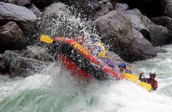
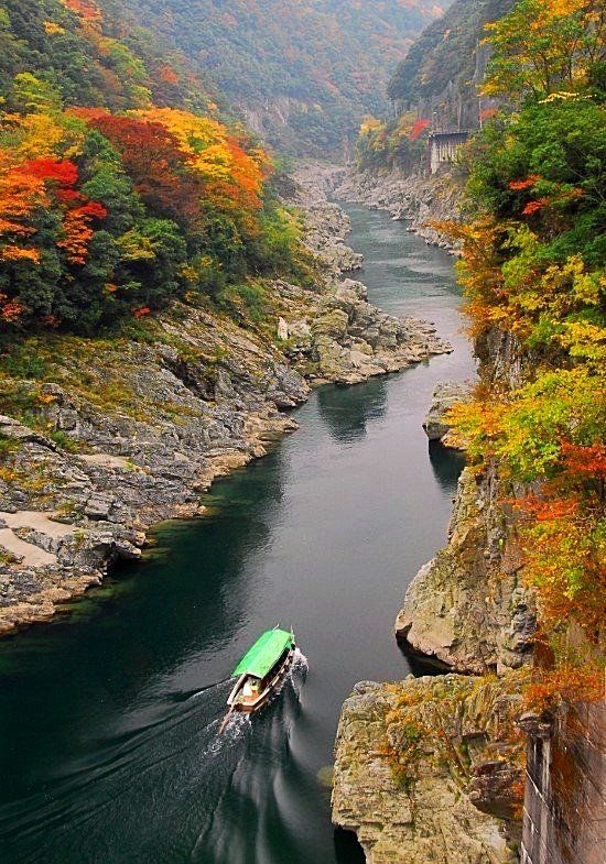
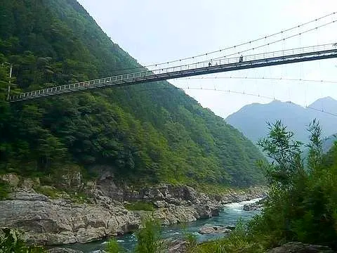
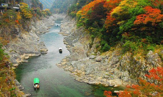
The ancient gorges of Oboke and Koboke are believed to have formed over 100 million years ago. Even though the Yoshino River flows through here, linking the vast interior of Shikoku with the ocean on the eastern coast, due to the intense rapids of the gorges this has never been much of a navigable waterway. Along with the steep "dangerous walking" of the gorge area,  the natural bottleneck formed here prevented the southern part of the area from being much of a transit point. 


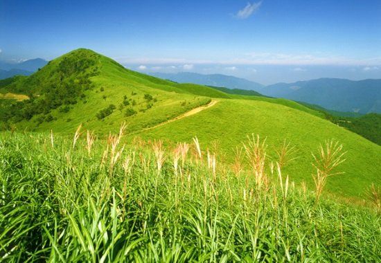
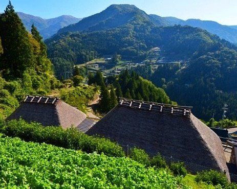
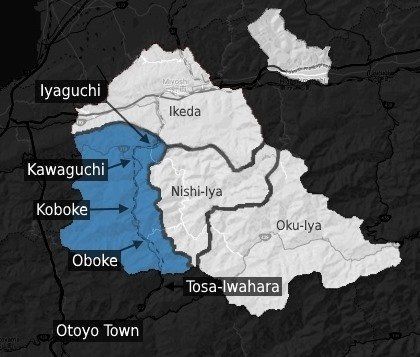
However, travelers did regularly pass through the northern section of the area via Kawaguchi, and there are several historic sites around here. The name "Yamashiro", for which the whole area is officially known, translates as "mountain castle" and indeed, in the northern part are the remains of the ancient Taojyo-Ato fortress. Like the Iya Valley, the people who settled in the area did so on the slopes of the mountains, being that there was a complete lack of flat space. Accordingly, the food culture revolved around what could be grown in such conditions.  


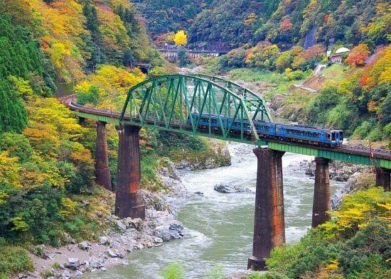
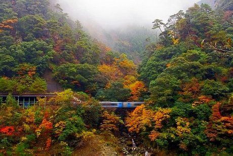
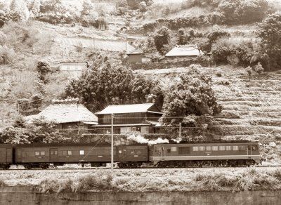
Also like the Iya Valley, much of the area was cut off from the rest of the country until roads were finally built in the early 20th century. The train line was opened during the 1930s, and with this not only was the south of Shikoku linked with the north, but this brought forth a wave of traders and travelers from across Japan, opening the beauty of the region to the outside world.

Climate of Oboke & Koboke

Even though the area is filled with mountains, most of the development and settlements are not at the higher elevations, so the temperature is not really affected much from altitude. The northern parts near Iyaguchi and Kawaguchi can get fairly hot and humid in summer much like coastal areas, however in the evening it does cool off nicely due to the surrounding forests and mountain breezes.  As one moves south towards Oboke, the mountains grow steeper and higher, placing many points in the shade for much of the day. 

The rafting season begins in April and is intensified by the rains of the early summer. By mid-summer the chance for typhoons increases, and Shikoku will usually be affected by a few each year. Due the enormous amount of rain that can come with such a storm and how the mountainous landscape channels the rainfall into the rivers, typhoons can sometimes close the river to rafting for up to several days. Also, small landslides can occur with typhoons, and the narrow Rt 32 that cuts along Oboke Gorge can be affected. During larger storms this main road may be closed for safety reasons. If so, detour routes are posted as one approaches.
The rafting season ends in November when the waters become a bit too cold for comfort. Early November is when the leaves change for Oboke and Koboke Gorges and colors continue for much of the month. Winter snow is usually minimal in parts near the river, though the upper elevations and the Shiozuka Highlands do get their fair share of snowfall.
Current weather and forecast for Oboke Gorge (Yamashiro-cho, Kamimyo).
Click on the blue weather bar for complete forecast information (offsite). 
Oboke Gorge OBOKE & KOBOKE

Oboke & Koboke
Top Things to See & Do

  • Oboke Gorge Pleasure Boat Tours

    Pleasure Boat Tours

    Enjoy the gorges without having a heart attack

    Classes & Tours

    Button
  • Oboke & Koboke
    Local Points and Access Map

    For best view of Map and Listings, hold device horizontally.
    Unkai over Oboke

    Unkai : A Sea of Clouds

    This section of the Yoshino River Valley is well known for being a place to view the rare unkai phenomenon. Meaning "Sea of Clouds", unkai occurs when fog settles into the bottom of a valley and the surrounding mountains peek out like islands. The local people here also have their own name for this natural wonder, calling it "Hachi-go-Giri". Spring and autumn are usually the most reliable time to see unkai, as the changing seasons provide the necessary conditions of humidity and day/night temperature differences, however it has also been known to happen in summer and even winter. 
    To see this glorious sight you need to do two somewhat challenging things: get up high, and get up early. Obviously, since seeing unkai from above is important, (instead of from within the fog below) its necessary to be at a higher elevation, at least 100 to 200m in elevation above the valley floor. The Oboke and Koboke Area has several locations noted as "Unkai Viewing Spots" including Ahashi Viewpoint  and Kunimi Upper Trailhead . Also, the fog settles in this way during the night, so from first light to about an hour or two after sunrise would be when it's visible before fading away. Aside from it never looking the same, do note that unkai forming is far from guarenteed though the chance of seeing it here is a bit more common than elsewhere. 

    IyaTime's Insider Tips

    IyaTime's

    Insider Tips

    If planning to come in early April, make an effort to see the Shiozuka Highlands Burning. Each spring the meadows up here are lit with controlled lines of flame that stretch like firey snakes across the mountain tops. The burning helps maintain a natural balance of vegetation. When viewed at night, its simply amazing.
    If riding through Oboke and Koboke via public bus from Ikeda, try to get a seat on the left hand side of the bus. The road is entirely on the right (west) side of the Yoshino River, giving the left side of vehicles when heading south to Oboke the best view (and vice-versa if heading north and/or towards Ikeda). Note: if continuing up into the Iya Valley, you may want to jump over to the other side of the bus (see the Iya Valley Tips).

    If coming in by train, either side can be OK as the train crosses the river between the two gorges, though views are sometimes obscured by tunnels.
  • Train bridge over the Yoshino River in Oboke Gorge

    City skyline

    Photo By: John Doe

    Button
  • Take a walk through the Oboke Gorge. From JR Oboke Station, cross the bridge and head north on Rt 32. For the first 25-30 minutes or so there is not much of a sidewalk and no view, but once past the Michi-no-Eki Oboke (good for a pit stop) and then Mannaka Service Area (river boat station) the main section of the gorge begins. Though there will be cars and trucks driving past, the walkway through the gorge is well appointed while your attention is taken by natural beauty. Head to WestWest Service Area, about 2.5km (40-50 minutes) from Mannaka Service Area and the first point out of the gorge, where you can have something to eat or find a beer to quench your thirst. Opt to take a bus or taxi back through or continue to JR Koboke Station. Or if you need to rest your weary bones, consider a hotspring bath: the SunRiver Oboke is soon after WestWest and the Hotel Mannaka is back up by Mannaka Service Area. This walk is detailed more on the Transport Page under "Travel by Walking & Hitchhiking".
    If you happen to find yourself waiting for a train or bus at JR Oboke Station don't just stand there looking at your cell phone. Across the train tracks is a small riverside park with great views of the bridge and of the flowing river. Or walk a few dozen steps up the hill to Boke Mart for a snack and a drink. Across from the main shop is their self-serve cafe with light meals, local tea, and cold beer available. And if the weather is nice you can choose to sit outside at their small roadside patio that overlooks the station. Or for the best view, walk up to the Oboke Bridge where you can look down from above at the thrilling Yoshino River.
  • Yokai Statue at Oboke Station

    Blurred Lines

    Photo by: John Doe

    Button
  • Train passing through Oboke Gorge in autumn

    City skyline

    Photo By: John Doe

    Button
  • Old Ogawa Bridge in Iyaguchi

    Fashion Magazine

    Photo By: John Doe

    Button
  • Looking to try some wild game meat? Then be sure to head over to the cafe & jibie inside the Michi-no-Eki Oboke and get one of their massive deer or wild boar burgers. The meat is hunted locally in the Iya Valley. You can also enjoy stellar views of Oboke and the river (so you can gorge yourself in the gorge!) and have some of their tasty desserts and drinks as well.    
    We at IyaTime love our bridges, and throughout Oboke & Koboke there are lots of interesting spans over the Yoshino River that come in all shapes and sizes. Aside from several vehicle bridges, two awesome wire suspension foot bridges span the river within Koboke, the Kunimasa Bridge and the Akagawa Bridge , both with fantastic views of the river and gorge. 
    If visiting in the spring, be sure to check out the array of fluttering carp flags that are hung up over Oboke Gorge. Its best to see them from the Mannaka Service Area which is where the gorge's Pleasure Boat Cruises also depart from. Dozens of these colorful banners are strung over the gorge for several weeks in honor of Children's Day on May 5th.  

    Oboke & Koboke
    Main Events

    Children's Day Carp Flags over Oboke Gorge 
    Other Areas

    Oboke & Koboke
    Local Points and Access Map

    For best view of Map and Listings, hold device horizontally.
    Share by: