
The Iya Valley
Hiking Portal
The Iya Valley is surrounded by some of the most beautiful mountains in Shikoku and offers a range of trails, camping, mountain huts, and a wealth of spectacular views. Hikes from a few hours to multiple days are possible, with some routes not needing much experience, skill or gear (hikes up to Mt. Tsurugi are possible even for beginners). For sure, to hit the trails and experience the natural beauty of Iya's mountains is certain to please anyone!
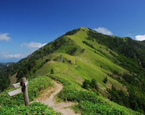
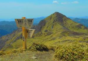
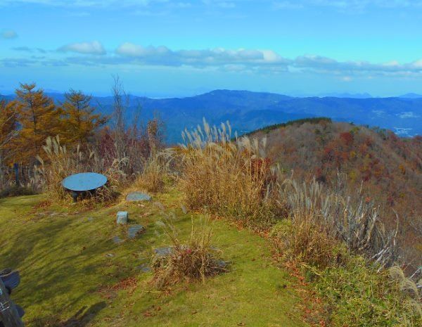
The highest mountain in Tokushima Prefecture and second highest in western Japan, Mt Tsurugi is one of Japan's "100 Famous Mountains". A popular mountain to climb, it's not too difficult, and the trails are all easy to follow. Steeped in legend, its name translates as "Sword Mountain" stemming from the folklore that the Emperor's ancient sword is buried here. Other treasure is also supposedly hidden here, (as well as monster snakes!), and to learn more, check our detailed Mt Tsurugi Page .
Mt. Tsurugi
Elevation: 1955m (6414 ft)
剣山 "Tsurugi-san"
Local name: "Ken-zan"
Hiking time (main trailhead to summit):
- 1:35 to 2:05 hours up (hiking only)
- 0:55 to 1:10 hours up (chairlift and hiking)
Main Trailhead:
- Tsurugi Trailhead (elev:1420m), Minokoshi, Oku-Iya
Facilities at Tsurugi Trailhead:
- Parking, shops, toilets, water, Wi-Fi, guesthouses
- Small nature museum
- Tsurugi Shrine & Enpukuji Temple
- Tsurugisan Bus Stop
- Chairlift from Minokoshi base to Nishijima (about half-way up)
Facilities on Mountain:
- Campground at Nishijima (free)
- Tsurugi Chojou Hutte on summit (staffed accommodation, restaurant) website
- Toilets at Nishijima Chairlift Station, and on summit
- Water springs at Nishijima and along trails
There are several possible routes up and down Mt Tsurugi, either with or without the chairlift.
| Click Route to See on Map | Time Up |
Time Down |
Difficulty (going up) |
Trailhead |
|---|---|---|---|---|
| Chairlift + main Tsurugi Trail | lift 15 hike 55 |
hike 45 lift 15 |
1.5 | Chairlift at Minokoshi |
| Chairlift + Ridge Trail | lift 15 hike 40 |
hike 30 lift 15 |
2.2 | Chairlift at Minokoshi |
| Base Route A + main Tsurugi Trail | 1:50 | 1:30 | 2.1 | Tsurugi Trailhead at Minokoshi |
| Base Route A + Ridge Trail | 1:35 | 1:15 | 2.2 | Tsurugi Trailhead at Minokoshi |
| Base Route B + main Tsurugi Trail | 2:05 | 1:40 | 1.5 | Tsurugi Trailhead at Minokoshi |
| Base Route B + Ridge Trail | 1:50 | 1:25 | 2.2 | Tsurugi Trailhead at Minokoshi |
| Difficulty Scale:
Difficulty is based on trail conditions, not overall length of hike |
||||
| 0 - | 1 - | 2 - | 3 - | 4 - |
| Flat or gradual hills | Easy or moderate climbs | Sometimes steep but not too tough | Climbs are often steep | Long steep climbs |
For complete trail descriptions , access info, and more details about hiking the mountain, check out the main Mt Tsurugi Page.
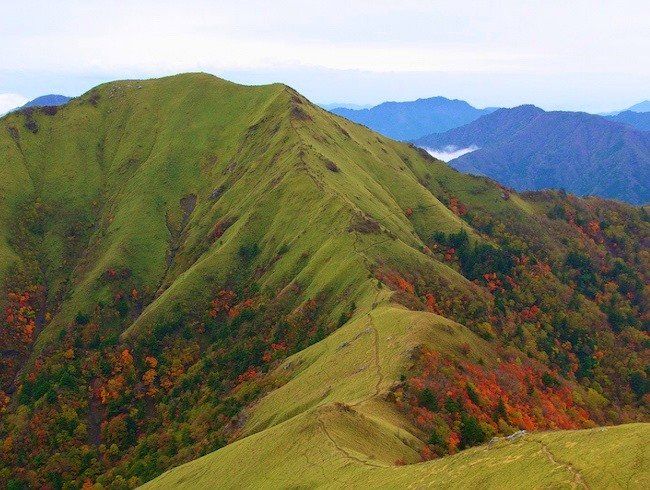
The second highest mountain in the Iya Valley and Tokushima Prefecture (though the tip of the summit is technically just outside of the town's boundary), Jirogyu is the less visited neighbor to Mt Tsurugi and its name is actually a traditional way to say "younger brother". This rugged, undeveloped mountain offers not only a very rewarding and beautiful hike along the expansive ridge, but the stunning 360 view is arguably better from its summit than from its "older brother". A great addition to any Mt Tsurugi hike, or just head directly for it along the South Ridge.
Elevation: 1930m (6332 ft)
次郎笈 "Jirogyu"
Hiking time (main trailhead to summit):
- 2:25 hours up (hiking only)
- 1:45 hours up (chairlift and hiking)
Main Trailhead:
- Tsurugi Trailhead (elev:1420m), Minokoshi, Oku-Iya
Facilities at Tsurugi Trailhead:
- Parking, shops, toilets, water, Wi-Fi, guesthouses
- Small nature museum
- Tsurugi Shrine & Enpukuji Temple
- Tsurugisan Bus Stop
- Chairlift from Minokoshi base to Nishijima
Facilities on Mountain:
- None, but many facilities are on nearby Mt Tsurugi
- Jirogyu Water Spring on bypass trail below summit
More Info:
Since the Jirogyu is located just next to Mt Tsurugi, we give complete trail descriptions for climbing Mt Jirogyu on the
Mt. Tsurugi page .
| Click Route to See on Map | Time Up |
Time Down |
Difficulty (going up) |
Trailhead |
|---|---|---|---|---|
| Promenade Route (w/ chairlift) | 1:45 | 1:35 | 2.2 | Chairlift at Minokoshi |
| Promenade Route (no chairlift) | 2:25 | 2:00 | 2.2 | Tsurugi Trailhead at Minokoshi |
| From Tsurugi Summit | :55 | :55 | 2.2 | Mt Tsurugi Summit |
| South Ridge via Mt Maruishi | 3:40 | 2:35 | 4.2 | Maruishi Trailhead at Double Vine Bridges |
| Full descriptions of these Mt Jirogyu routes are given on the Mt Tsurugi page . On there, open the Full Screen Map for trail info, and look under "Optional Trails" to specific details about hiking these trails to Jirogyu, including the trail via Mt Maruishi. | ||||
| Difficulty Scale:
Difficulty is based on trail conditions, not overall length of hike |
||||
| 0 - | 1 - | 2 - | 3 - | 4 - |
| Flat or gradual hills | Easy or moderate climbs | Sometimes steep but not too tough | Climbs are often steep | Long steep climbs |
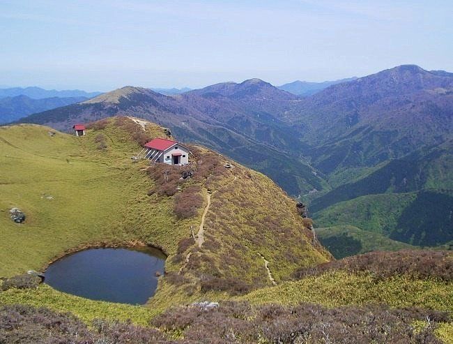
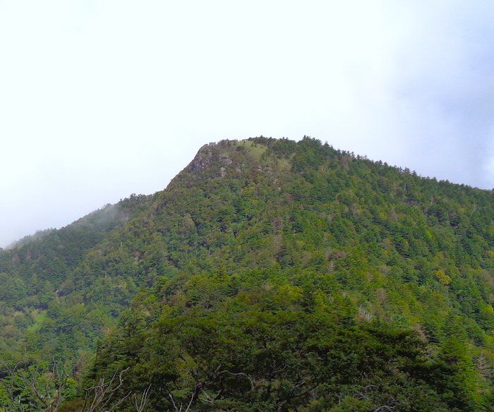
Often mistaken as Iya's and Tokushima's 2nd highest mountain (Mt Jirogyu is higher), this 3rd highest peak of Iya is quite popular because its so lovely on top, but far fewer people visit here than Mt Tsurugi. The large unstaffed hut near the summit sits beside a pretty pond.
Elevation:1893m (6210 ft)
三嶺 "Miune"
Local name: "San-rei"
Main Trailhead:
- Miune Trailhead (elev: 915m), Nagoro, Oku-Iya
Hiking time (Miune Trailhead to summit):
- 3:15 hours up
Facilities at Miune Trailhead:
- Parking, water, toilets
- Nagoro Bus Stop (5 min walk)
Facilities on Mountain:
- Water spring near summit
- Large free hut (no staff) near summit
- Pit Toilet near hut
| Click Route to See on Map | Time Up |
Time Down |
Difficulty (going up) |
Trailhead |
|---|---|---|---|---|
| Nagoro Route | 3:15 | 2:05 | 3.0 | Miune Trailhead at Nagoro |
| Sugeoi Route | 4:00 | 2:50 | 4.0 | Sugeoi Trailhead at Iyashi-no Onsenkyo Hotel |
| South Ridge via Tengu Pass | 5:45 | 4:30 | 4.2 | Izari-touge Trailhead near Kubo |
| It is also possible to access Mt. Miune in a multi-day South Ridge hike. Some options would be to/from Minokoshi (via Mt Tsurugi), to/from Oku-Iya Double Vine Bridges, or to/from Kyobashira Pass. All of these hikes would require staying overnight (hut or tent) along the way, and all would be with Difficulty Rating of about 3.5+ but they are all beautiful hikes. | ||||
| Difficulty Scale:
Difficulty is based on trail conditions, not overall length of hike |
||||
| 0 - | 1 - | 2 - | 3 - | 4 - |
| Flat or gradual hills | Easy or moderate climbs | Sometimes steep but not too tough | Climbs are often steep | Long steep climbs |
For complete trail descriptions , trailhead access, and more details about hiking the mountain, check out the main Mt Miune Page .
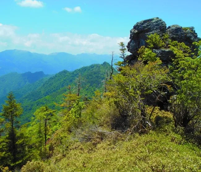
The pyramid shaped Mt. Tenguzuka blasts up triumphantly from a broad grassy ridge (called "Ushi-no-Se" or "Cow's Back"). Though not so popular due to being a bit out of the way (you may not see anybody else), it is not only a beautiful summit, but the surrounding hike in along the ridge is spectacular. One of our favorite peaks in Iya, its great either on its own or connected with a Mt Miune hike (consider staying in nearby Okameiwa Hut or the hut on Mt Miune).
Elevation: 1812m (5945 ft)
天狗塚 "Tenguzuka"
Main Trailheads:
- Tenguzuka Trailhead (elev: 1135m), near Nishiyama, Oku-Iya
- Izari-touge Trailhead (elev: 635m), near Kubo, Oku-Iya
Hiking time (main trailheads to summit):
- 2:15 hours up (Tenguzuka T.H.)
- 3:45 hours up (Izari-touge T.H.)
Facilities at Upper Tenguzuka Trailhead:
- Parking
Facilities at Lower Tenguzuka Trailhead:
- Kubo Bus Stop (15 min walk) toilets there
Facilities on Mountain:
- No facilities on mountain
- Okameiwa Hut about 1 hour from summit
| Click Route to See on Map | Time Up |
Time Down |
Difficulty (going up) |
Trailhead |
|---|---|---|---|---|
| Tenguzuka Main Route (Tenguzuka T.H.) |
2:15 | 1:35 | 3.0 | Tenguzuka Trailhead near Nishiyama |
| Tenguzuka Main Route (Izari-touge T.H.) |
3:45 | 2:35 | 4.0 | Izari-touge Trailhead near Kubo |
| South Ridge via Mt. Miune (Miune T.H.) |
5:45 | 4:45 | 3.0 | Miune Trailhead at Nagoro |
| South Ridge via Mt. Miune (Sugeoi T.H.) |
6:30 | 5:30 | 4.0 | Sugeoi Trailhead at Iyashi-no Onsenkyo Hotel |
| It is also possible to access Mt. Tenguzuka in a multi-day South Ridge hike. Some options would be to/from Minokoshi (via Mt Tsurugi), to/from Oku-Iya Double Vine Bridges, or to/from Kyobashira Pass. All of these hikes would require staying overnight (hut or tent) along the way, and all would be with Difficulty Rating of about 3.5+ but they are all beautiful hikes. | ||||
| Difficulty Scale:
Difficulty is based on trail conditions, not overall length of hike |
||||
| 0 - | 1 - | 2 - | 3 - | 4 - |
| Flat or gradual hills | Easy or moderate climbs | Sometimes steep but not too tough | Climbs are often steep | Long steep climbs |
Trail descriptions for Mt Tenguzuka as well as access details for its trailheads can be found on the Mt Miune page.
The highest peak among the mountains of the north ridge, the hike out to Mt Yahazu is not too strenuous and offers quiet solitude. The trail goes in and out of primeval forest as you hike along the ridge, and the summit offers a majestic panoramic view of the entire south ridge mountains.
Elevation: 1849m (6067 ft)
矢筈山 "Yahazu-san"
Main Trailhead:
- Ochiai Pass Trailhead (elev: 1520m), Ochiai, Oku-Iya
Hiking time (Main trailhead to summit):
- 1:45 hours up
Facilities at Ochiai Pass Trailhead:
- Parking, toilets
- Two crummy huts (opposite directions) are within a 5 or 10 minute walk from the pass. The better one of the two is along the road.
- Water can be found about 1km down the road towards Ochiai
Facilities on Mountain:
- None
| Click Route to See on Map | Time Up |
Time Down |
Difficulty (going up) |
Trailhead |
|---|---|---|---|---|
| Ochiai Pass Route | 1:45 | 1:20 | 2.3 | Ochiai Pass Trailhead |
| On some hiking maps (in Japanese) the hiking time for the trail from Ochiai Pass to Mt. Yahazu is said to be about 2.5+ hours going up (and about 2 hours going back). Unless you are walking really slow, it should be much quicker than that. However, at one point about one hour into the hike there is a particularly steep section which has ropes available, but its only a few minutes long. | ||||
| Difficulty Scale:
Difficulty is based on trail conditions, not overall length of hike |
||||
| 0 - | 1 - | 2 - | 3 - | 4 - |
| Flat or gradual hills | Easy or moderate climbs | Sometimes steep but not too tough | Climbs are often steep | Long steep climbs |
The name Eboshi refers to a type of traditional Japanese hat, and the mountain takes the name because its wedge-shape peak resembles this hat design. The ridge route from Oboke Pass is a little bit challenging, crossing several small peaks in between with lots of fine views. But the Loop route via Eboshi Trailhead is rough and is not for beginners!
Elevation: 1669m (5475ft)
烏帽子山 "Eboshi-yama"
Main Trailheads:
- Ochiai Pass Trailhead (elev: 1520m), Ochiai, Oku-Iya
- Eboshi Trailhead (elev 1085m), Oku-Iya *difficult route
Hiking time (Ochiai Pass to summit):
- 2:10 hours up
Facilities at Ochiai Pass Trailhead:
- Parking, toilets
- Two crummy huts (opposite directions) are within a 5 or 10 minute walk from the pass. The better one of the two is along the road.
- Water can be found about 1km down the road towards Ochiai
Facilities on Mountain:
- None
| Click Route to See on Map | Time Up |
Time Down |
Difficulty (going up) |
Trailhead |
|---|---|---|---|---|
| Ochiai Pass Route | 2:10 | 2:00 | 3.0 | Ochiai Pass Trailhead |
| Eboshi Trailhead Route | 2:00 | 1:30 | 3.5 | Eboshi Trailhead |
| Eboshi - Ochiai Pass Loop** | 5:25 | 5:25 | 4.0 | Ochiai Pass Trailhead |
| **The Eboshi - Ochiai Pass Loop route is rather challenging and not suitable for beginners. It should not be done alone since there are several technical and very steep parts going to/from the Eboshi Trailhead area where injury can happen. Also, the route between Eboshi Trailhead and Ochiai Pass has several collapsed bridges which would be difficult to cross if raining, and the trail itself through here is badly marked. | ||||
| Difficulty Scale:
Difficulty is based on trail conditions, not overall length of hike |
||||
| 0 - | 1 - | 2 - | 3 - | 4 - |
| Flat or gradual hills | Easy or moderate climbs | Sometimes steep but not too tough | Climbs are often steep | Long steep climbs |
With a name meaning "Country View", the fantastic panoramic expanses seen from the summit are wonderful. With the Lower Trailhead accessible via local bus, or even (with some effort) possible to hike from JR Oboke Station, it is the closest bald-top mountain to central Nishi-Iya and Oboke. Though not too long of a walk, especially if going from the Upper or Deep Trailheads, do realize that it is still a rather hearty hike with a decent amount of constant uphill climbs.
Elevation: 1409m (4622 ft)
国見山 "Kunimi-san"
Main Trailheads:
- Deep Kunimi Trailhead (elev: 1175m), Oboke
- Upper Kunimi Trailhead (elev: 1040m), border of Oboke and Nishi-Iya
- Lower Kunimi Trailhead (elev: 781m), border of Oboke and Nishi-Iya
- Oboke - Kunimi Trailhead (elev: 202m), Oboke
Hiking time (main trailheads to summit):
- 45 min up (Deep T.H)
- 1:10 hours up (Upper T.H.)
- 2:00 hours up (Lower T.H.)
- 4:15 hours up (Oboke T.H.)
Facilities at Upper & Deep Kunimi Trailheads:
- Parking
Facilities at Lower Kunimi Trailhead:
- "Touge" Bus Stop via Local bus (van)
- Parking
- Small mountain shrine
Facilities near Oboke-Kunimi Trailhead:
- Bus, train, shops, parking
Facilities on Mountain:
- Kunimi Mountain Shelter (suitable only in an emergency)
| Click Route to See on Map | Time Up |
Time Down |
Difficulty (going up) |
Trailhead |
|---|---|---|---|---|
| Kunimi Main Route (Upper T.H.) |
1:10 | 0:50 | 3.0 | Upper Kunimi Trailhead via access road |
| Kunimi Main Route (Lower T.H.) |
2:00 | 1:30 | 3.0 | Lower Kunimi Trailhead at "Touge" Bus Stop |
| Deep Kunimi Route (via Old Kunimi Trail) (Deep T.H.) |
0:45 | 0:35 | 2.8 | Deep Kunimi Trailhead via access road |
| Kunimi Loop Route (Upper T.H.) |
2:30 | loop | 3.0 | Upper Kunimi Trailhead via access Road |
| Old Kunimi Trail from Oboke (Oboke-Kunimi T.H.) |
4:15 | 3:00 | 4.0 | Oboke-Kunimi Trailhead near JR Oboke Station |
|
||||
| Difficulty Scale:
Difficulty is based on trail conditions, not overall length of hike |
||||
| 0 - | 1 - | 2 - | 3 - | 4 - |
| Flat or gradual hills | Easy or moderate climbs | Sometimes steep but not too tough | Climbs are often steep | Long steep climbs |

Looking to hike the awesome bounty of Japanese mountains beyond the Miyoshi area? Check out the Hike Master Japan website for a variety of hiking routes located all across the country, which has detailed info in English, trail maps, and fantastic photos!