
Also on offer here is a pretty waterfall that splashes down just below the husband's bridge, as well as the option of wading through the crystal clear waters of the Iya River. And what's fun for anyone is to try the free "Yaen" Monkey Cart which also spans the river here. This old-style contraption is essentially a small (up to 3 people) wood cart that slides over the river via wires, and the occupants need to pull themselves across. Perhaps it is an even more unique way to cross a river than via a bridge made of vines.
Oku-Iya Niju Kazurabashi
The Double Vine Bridges
奥祖谷二重かずら橋
Area:
Type:
no photo
Tucked way in the deepest part of the Iya Valley, the Double Vine Bridges
are more than worth the effort of visiting. This pair of hidden gems are set within dense forest, which offers a peaceful and fully natural atmosphere. Along with the more famous (and accordingly more crowded) Iya-no-Kazurabashi
in Nishi-Iya, these three spans are the last remaining vine bridges in the Iya Valley, which was once home to thirteen of them.
The two spans of Oku-Iya symbolize a couple, with the higher bridge dubbed the male / husband bridge, and the lower bridge being the female / wife bridge (though the female bridge is actually about 100 meters further up in the valley than the male bridge).
Unlike the Iya-no-Kazurabashi in Nishi-Iya, there is no development or businesses in the area surrounding these bridges, only virgin forest. Also different is the availability, in that the area is more like a nature park than a singular tourist attraction, such that after paying the entrance fee up by the roadside, you can stay for as long as you want, cross the bridges repeatedly, and even bring along lunch to eat at either the tables by the neighboring campground or even spread out a picnic upon the large river-side stones between the two spans (aside from the bus loads of group tourists there, at the Nishi-Iya Kazurabashi one can only cross that bridge once one-way for the same fee, river access there is a bit difficult, and the vehicle bridge that crosses beside it kinda takes away from the feeling of tranquility.)
Address:
Phone:
Website:
Hours:
Price:
My trip
Click any place
to see on map.
Local Points
To get to the Double Vine Bridges requires a 100 or so meter walk down a paved mountain path through the forest from the roadside entrance (there are many steps, so it is not wheelchair accessable). The surrounding area is undeveloped and serenely beautiful, with paths leading down to the river.
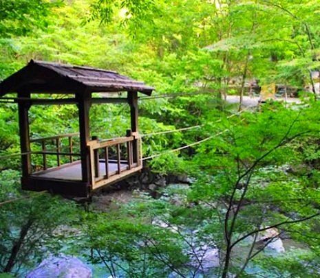
The Oku-Iya Niju Kazurabashi Campgroud is located up by the wife's bridge, as well as a set of toilets. Next to here is the "Yaen" Monkey Cart , where one can pull themself across the river via suspended wire cart. Heading up from the campground is a tranquil and fairly level nature trail that follows the river up for a kilometer or so, while the trailhead to Mt Maruishi is back below the husband's bridge near the waterfall. Up along the road is Maruishi Parkland restaurant and souviner shop, which is the only facility of any sort in the area.
The Oku-Iya Niju Kazurabashi Campgroud is located up by the wife's bridge, as well as a set of toilets. Next to here is the "Yaen" Monkey Cart , where one can pull themself across the river via suspended wire cart. Heading up from the campground is a tranquil and fairly level nature trail that follows the river up for a kilometer or so, while the trailhead to Mt Maruishi is back below the husband's bridge near the waterfall. Up along the road is Maruishi Parkland restaurant and souviner shop, which is the only facility of any sort in the area.
Access by Car
By car, the Oku-Iya Double Vine Bridges
are on Rt 439 with free parking on either side of the entrance booth. They are about 75-80 minutes from Oboke,
and about 50-60 minutes beyond the Kazurabashi Area
down in Nishi-Iya. (Beyond the Kazurabashi and throughout all of Oku-Iya the road is mostly one-laned and often curvy.)
From Kyojo in Oku-Iya its about a 35-40 minute drive, and from Lower Ochiai Village its around 25-30 minutes. The closest settlement is at Nagoro (Scarecrow Village) about 10 minutes away by car.
There is nothing but forest between the Double Vine Bridges and the valley's final settlement of Minokoshi at the base of Mt Tsurugi. It takes about 15-20 minutes to drive between these two points.
Access by Bus
By bus, it can be a little tricky getting all the way the Niju Kazurabashi Bus Stop.
The main Shikoku Kotsu Buses which originate in Ikeda and go via Oboke and Nishi-Iya do not travel this far, with their last stop being at Kubo
in Oku-Iya (about 25 minutes by vehicle from the bridges). However, the Local Miyoshi Municipal Bus of Oku-Iya
does come out this far twice a day, but this bus only offers service as far as these bridges on limited days, which is only from early April to late November on every Saturday, Sunday, and Holiday, as well as every day during certain vacation periods (these are usually from the 4th Monday in April to the first Friday in May, from the 3rd Monday in July to August 31, and from October 1 to November 3). Going between here and Minokoshi
the Local Bus uses the same seasonal schedule (*though the bus from the bridges to Minokoshi starts a week later in the spring)
The final regular daily stop for the Local Miyoshi Municipal Buses (6 times a day) is at Nagoro (Scarecrow Village), about 4km away and possible to walk (see By Foot below).
**Again, these Local Buses do not connect to Nishi-Iya if traveling to/from there, so one must transfer between the Local Bus and the main Shikoku Kotsu Bus at Kubo or elsewhere in Oku-Iya where they share stops.
Access by Foot & Hiking
On foot, one can also walk to/from Nagoro
(Scarecrow Village) which is the last regularly scheduled bus stop for the Local Miyoshi Municipal Bus of Oku-Iya (6 daily buses go to Nagoro, but only 4 have connections at Kubo
with the main Shikoku Kotsu Buses for Nish-Iya, Oboke & Ikeda). Its about 4km from Nagoro and takes about 60-70 minutes to walk (a little more going up, a little less going down). Try sticking out your thumb for a ride if you see a car, though locals don't live out this far and most tourists don't regularly pick up hitch-hikers.
One can also hike via mountain trail to the bridges, being that this is also the trailhead for Mt Maruishi (located between Mt Tsurugi and Mt Miune). Depending if you use the Tsurugisan chairlift and/or actually go completely up to Mt Tsurugi's summit (there's a non-summit bypass trail that is quicker), its about a 4 to 6 hour hike from Minokoshi to the bridges (or about 5.5 to 8 hours from the bridges to Minokoshi). Hiking up to only Mt Maruishi is about 3 hours up from the bridges (and about 2 hours down), while going to/from Mt Miune along the ridge from here is considerably longer and would require either an early start or an overnight stay upon the mountains.
One can also hike via mountain trail to the bridges, being that this is also the trailhead for Mt Maruishi (located between Mt Tsurugi and Mt Miune). Depending if you use the Tsurugisan chairlift and/or actually go completely up to Mt Tsurugi's summit (there's a non-summit bypass trail that is quicker), its about a 4 to 6 hour hike from Minokoshi to the bridges (or about 5.5 to 8 hours from the bridges to Minokoshi). Hiking up to only Mt Maruishi is about 3 hours up from the bridges (and about 2 hours down), while going to/from Mt Miune along the ridge from here is considerably longer and would require either an early start or an overnight stay upon the mountains.